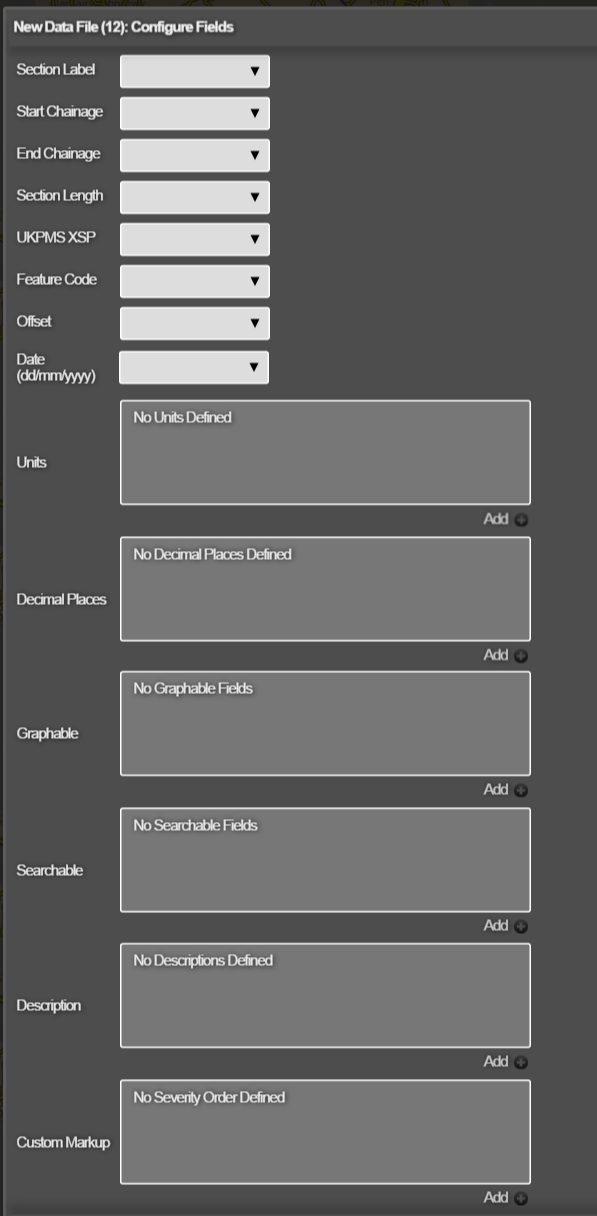
Configuring Data Import Fields
The Data Import configuration identifies certain data fields to Horizons and can provide extra information about them, for example to specify section references, item coordinates in CSV files, field descriptions, and units. There are two ways to do this:
- Within Horizons. See below.
- By downloading a data import configuration file, editing it directly with Excel, and then uploading it again. See Downloading and Editing a Data Import Configuration File.
To configure the Data Import fields in Horizons
- In the Management module Data Import drop-down, do one of the following:
- Click Add import and import a new data file (see Importing and Configuring Data).
- Select an existing unprocessed data import item to configure. The Configure Data Import window opens.
- Click the spanner icon beside the uploaded files. The Configure Fields window opens.
</div>
The Configure Fields window
The Configure Fields window defines a data import configuration for the data file that you are importing.The Configure Fields window enables you to give meaning to the data to be imported by describing either the attributes in GIS files or, similarly, columns in CSV files. You can save and download this configuration as a file to use again for data files with a similar format. See Downloading and Editing a Data Import Configuration File. This topic provides an example of a data import configuration file that shows the mapping between Horizons fields and the columns in an example data file.
- Select which of your data columns represents various Horizons fields, as described in the following table:
This table describes the mapping of fields in the data file, as well as explaining the fields in the Horizons Configure fields window.
Section Label
Input Type - References In Data
Set the Section Label field to the appropriate column in your data. The field/column in the uploaded data file containing the Section references must map to IsSectionLabel in the data import configuration file.
Start Chainage
Input Type - All
Identify the field/column in the uploaded data file that contains the start chainage value. Where section references are provided, specify the Start and End Chainage values to indicate the location of the item along the Section. Data that has only a Start Chainage is considered to be point data. Data that has Section references but no chainage fields is considered to be whole section data. The field/column in the uploaded data file containing the start chainage must map to IsStartChain in the data import configuration file.
End Chainage
Input Type - All
Identify the field/column in the uploaded data file that contains the end chainage value. Where section references are provided, specify the Start and End Chainage values to indicate the location of the item along the section. Data that has no End Chainage is considered to be point data. Data that has section references but no chainage fields is considered to be whole section data. The field/column in the uploaded data file containing the end chainage must map to IsEndChain in the data import configuration file.
Section Length
Input Type - All
Identify the field/column in the uploaded data file that contains the Section length value. The field/column in the uploaded data file containing the Section length must map to IsSectionLength in the data import configuration file.
UKPMS XSP
Input Type - All
Identify the field/column in the uploaded data file that contains the XSP value. Each item within the data file can contain a field to hold the UKPMS Cross Sectional Position or XSP of the item on a Section. This field is optional. If the data imported is to be used for Analysis, the XSP must be provided. It is required in order to position the data into the appropriate lane. Data can be forced onto a specific user-defined XSP during import thereby overriding anything specified in the file. The field/column in the uploaded data file containing the XSP must map to IsUkpmsXSP in the data import configuration file.
Feature Code
Input Type - All
Identify the field/column in the uploaded data file that contains the UKPMS feature code value. Horizons can attribute data against different feature codes (asset types) such as Carriageway (CW), Footway (FW), Cycletrack (CT) and Verge (VG). If there is no specified asset type, the feature code defaults to Carriageway. In the data import configuration file, field containing the UKPMS feature code is indicated using the IsUkpmsFeatureCode setting.
Offset
Input Type - CSV without Geometry
Identify the field/column in the uploaded data file that contains the Offset value. Where no geometry is available within a CSV file, you can specify the offset from the section centreline. Offset is the distance in metres of the item from the section centreline. Positive values of offset move items to the right of the centreline with respect to the UKPMS section direction as described by the geometry. Negative values move items to the left.
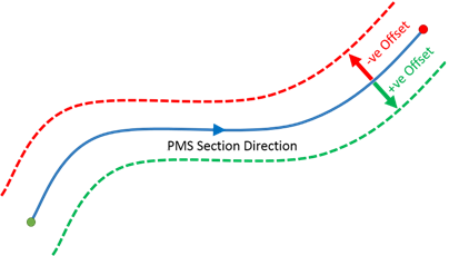
The field/column in the uploaded data file containing the offset must map to IsOffset in the data import configuration file.
Date
Input Type - All
Identify the field/column in the uploaded data file that contains the date. Date must follow the dd/mm/yyyy format. If left blank, the date set for the import will automatically be populated.
If you’re importing accident data to use in a SCRIM Prioritisation Model, the Date field must be configured. Otherwise, the layer won’t appear in the Accident Layers drop down list.
Geometry Type
Input Type - CSV With Geometry
Geometry information is used to spatially match each item to a Network Section. CSV files with geometry must specify the item coordinates. Define which fields represent geometry (point, line, or polygon). Select the geometry type:
- Line—
X1,Y1,X2,Y2 - Point—
X1,Y1 - Well Known Text (WKT) format—use this to define points, polylines, or polygons.
X1 Coord
Input Type - CSV With Geometry
Geometry Type - Point or Line
Identify the field/column in the uploaded data file that contains the geometry for the X1 coordinate. The column that contains the geometry for the X1 coordinate must map to csvX1 in the data import configuration file.
Y1 Coord
Input Type - CSV With Geometry
Geometry Type - Point or Line
Identify the field/column in the uploaded data file that contains the geometry for the Y1 coordinate. The column that contains the geometry for the Y1 coordinate must map to csvY1 in the data import configuration file.
X2 Coord
Input Type - CSV With Geometry
Geometry Type - Line
Identify the field/column in the uploaded data CSV file that contains the geometry for the X2 coordinate. The column that contains the geometry for the X2 coordinate must map to cvsX2 in the data import configuration file.
Y2 Coord
Input Type - CSV With Geometry
Geometry Type - Line
Identify the field/column in the uploaded data file that contains the geometry for the Y2 coordinate. The column that contains the geometry for the Y2 coordinate must map to cvsY2 in the data import configuration file.
Well Known Text
Input Type - CSV With Geometry
Geometry Type = WKT Geometry information can be represented by Well Known Text (WKT) markup language. WKT is used to represent spatial objects on a map. Identify the field/column in the uploaded data CSV file that contains the WKT for the object. The column that contains the geometry for the WKT must map to csvWKT in the data import configuration file.
Units
Input Type - All
You may optionally choose to specify the units for each numeric field/column. You can define units for each data field. The specified units are presented alongside the field value in Horizons where appropriate. In the data import configuration file, set the Units code as required for any numeric field.
Decimal Places
Input Type - All
Optionally specify the number of decimal places for each numeric field/column (default is 10 d.p.) The decimal places setting defines how the value of data in the field/column is to be displayed in Horizons to the user. It does not truncate or round the underlying data. In the data import configuration file, set the NumDP value as required for any numeric field.
Graphable
Input Type - All
Optionally specify which numeric fields/columns are graphable in Horizons. You can make field values visible in graph form in the Graphing function in Explorer. In the data import configuration file, set the IsGraphable setting to true (1) for each field that you wish to make graphable.
Searchable
Input Type - All
Optionally specify which text or ID fields/columns are searchable in Horizons. You can make field values searchable in the Search function in Explorer. This is only currently supported for text fields. In the data import configuration file, set the IsSearchable setting to true (1) for each field that you wish to make searchable.
Custom Markup
Input Type - URL
A valid URL for an imported image or link can be included in your upload. To arrange for bulk uploads of your data, please contact Causeway Support.
Description
Input Type - All Optionally specify a description for each field/column. The descriptions provided for Analysis “In Scheme” fields are used as the Condition Parameter name for that field in Analysis. If no description is provided, the field/column name is used. In the data import configuration file, set Desc as required for any field.
In Scheme
Input Type - All
Add the field(s)/column(s) in the uploaded data file to make them available for analysis. When importing data into Horizons, you can select specific fields to be made available as Condition Parameters in the Analysis module for modelling future condition. Data items that are used in analysis must have a valid XSP setting. In the data import configuration file, set InScheme to true (1) any field that you would like to use as a Condition Parameter in Analysis.
Severity Order
Input Type - All
For each “In Scheme” field above used as a condition parameter in analysis, you can specify whether the condition gets more severe as the values ascend or descend. This field sets the severity order for a data item that is used in analysis (see above). In the data import configuration file, for a parameter where the larger the value is, the more severe the condition is (e.g. Rutting), the SeverityAsc setting must be true. For a parameter where a smaller value is more severe (e.g. Texture), set SeverityAsc to false.
Data Type
Input Type - All
The data type for each field or column can be specified within the import configuration using the Type setting or left blank for automatic type allocation. You cannot set the data type in the Horizons Configure Fields window. However, you can specify the field type directly in the data import configuration file. Data for each field can be held in the following formats: Integer, Real, String, Time, Datetime.
- Click Save.
You can download the configuration for the data import as a configuration file to be used again for data files that contain the same fields. See Downloading and Editing a Data Import Configuration File.