Exporting a Layer
You can export a data Layer or the original data source as a CSV file or as a geospatial vector data file such as MapInfo and Shapefile. See also Exported Layer Fields.
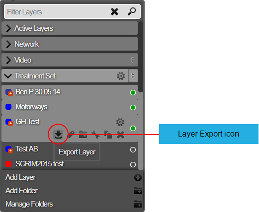
To export a data Layer
- In Explorer, in the Layer drop-down, select the Layer to export.
- Click the Layer Options icon for the required Layer and then click the Export Layer icon. The Export Layer icon is a downward pointing arrow. The Export Options window opens. The Export Layer icon appears in the Layer Options menu.
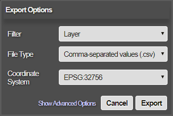
The Export Options window
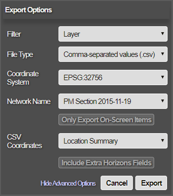
The Export Options Advanced window
The settings for the Export Options window are the following:
Filter
- Layer - Export the data Layer
- Data Source - Export the original data source from which the Layer was created.
File Type
The output format for the export
- Comma-separated values (.csv) - For use in spreadsheet applications.
- MapInfo (.tab) - For use in a MapInfo geographic information system.
- ESRI Shapefile (.shp) - For use in an Esri geographic information system.
Coordinate System
- British National Grid (Eastings-Northings) - The Ordnance Survey National Grid reference system.
- WGS84 (Longitude-Latitude) - Provides coordinates for geometry in the export.
- Specific EPSG code - You can provide the EPSG code for the coordinate system that you prefer.
Advanced Options
Network Map
Select the Network that the export should apply to. This is usually the Network that is currently selected. But if you have multiple Networks set up, select which one the export operation should apply to. If the data was loaded against an older version of your Network, you’ll have the option of exporting against the original Network.
Fit to Target Network
On or Off. This setting describes how Horizons deals with items of data that are beyond the range of target Sections, for example, that are not within the target Network destination.
Only Export On Screen Items
Only information on screen at time of export will be included.
CSV Coordinates
- Well Known Text - well-known text (WKT) is a standard text markup language for storing geometry coordinates in plain text.
- Location Summary - Use this to reference spatial objects as follows:
- Points - as x,y coordinates
- Lines - as start, midpoint, and end points
- Polygons — as bounding box and centroid
- None - no location information will be present in the export. Choose this option if the Section ID and Section count is sufficient.
Include Extra Horizons Fields
Allows for the export of fields not included by default in the export. See About Exported Layers. Select the required options for the export of the Layer, and click Export. The export starts immediately. The exported file is delivered to your normal Downloads folder.