Creating Deterioration Bounds Layer
You can create a Deterioration Bounds Layer for a selected parameter within the system. This allows you to display an overlay to see in a layer which sub-sections are deteriorating as expected, faster than expected or slower than expected for the selected parameter, for example cracking of the whole carriageway or rutting.
When you have generated the layer you can display the data on the map.
Before creating a Deterioration Bounds Layer you must set the deterioration bounds when configuring the deterioration curve for the parameter you want to display, see Define Deterioration Curve.
To create a Deterioration Bounds layer use the following procedure:
- In the Explorer Layers drop-down, click Add Layer.
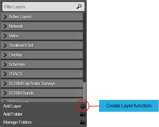
The Create Layer window opens.
- Enter the name of the new Layer.
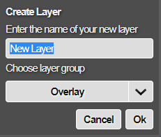
A Layer name must be unique in Horizons.
- The Layer Group is not required if this is the first Deterioration Bounds layer that you are creating and you can accept the default folder for the layer, alternatively you should select the Deterioration Bounds layer group, and click OK.
The Layer Setup window opens. In the Layer Type field select the Deterioration Bounds Layer.
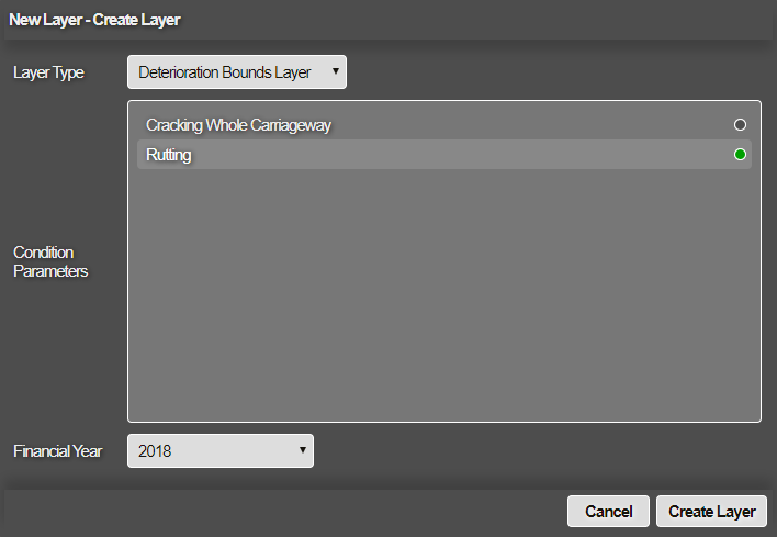
You must make selections in the following fields in order to create a layer:
Condition Parameters
The Condition Parameters displays a list of parameter for which deterioration bounds have been defined. You can select only one parameter that is used to create the layer.
Financial Year
This drop-down displays a list of financial years for the selected condition parameter for which survey data exists
When you select a year, for each sub-section the calculation considers the surveys in latest earlier year and earliest next year (including the year itself) across the selected year.
- When you have completed you selections, select the Create Layer button.
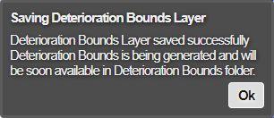
A notification indicates that the layer has been created and saved, select OK to return to the map. Once the bounds have been generated you will receive an email to indicate the actual success or failure of the calculations.
For the Condition Parameter and the Financial year selection, it is possible that the roads belonging to a particular asset group (for which bounds are defined) are not present in the survey data. The system will not proceed with the layer creation if this situation occurs.
You will receive an error message suggesting the asset groups for which bounds have to be defined first, to be able to create the Bounds layer for the chosen combination of condition parameter and financial year.
If you have defined bounds for a particular condition parameter but, no common roads and XSPs are surveyed for the selected combination of condition parameter and financial year, then you will receive an error message suggesting that the layer cannot be created for the selected combination.
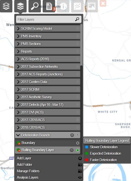
- When the Bounds layer is generated successfully, then the system creates a Deterioration Bounds layer group if it did not exist before. The new Bounds layer is placed within this layer group.
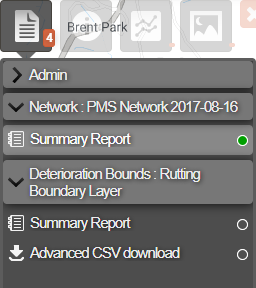
Deterioration Bounds Layer CSV Report Download
An Advanced CSV report download is provided for the deterioration bounds layer. After the deterioration bounds layer is created, use the Explorer module to display the layer. You can choose the layer and by visiting Reports tab, download the advanced CSV report for the layer.