Exporting Layers
Download exported Layer data
You can export the data of any Layer (or its original data source) as a downloadable CSV file or a geospatial vector data file (such as MapInfo or Shapefile). This makes it possible to use data from CausewayOne Asset Strategy in other applications.
To export a Layer:
-
Select the top Layers icon. In the dropdown, open the folder containing the relevant Layer.
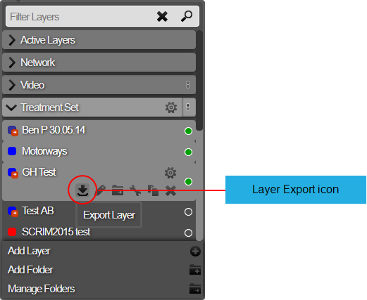
-
Hover over the Layer, select its Options icon, and then select the Export Layer icon that appears below it.
-
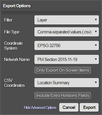
In the Export Options window, fill in the following fields as needed:
-
Filter - choose one:
-
Layer - export the Layer's data.
-
Data Source - export the original data source from which the Layer was created.
-
-
File Type - choose the output format:
-
Comma-separated values (.csv) - for use in spreadsheet applications.
-
MapInfo (.tab) - for use in a MapInfo geographic information system.
-
ESRI Shapefile (.shp) - for use in an Esri geographic information system.
-
-
Coordinate System - specify the system used to exported geometry data
-
Easting / Northings (BNG) - the British National Grid system. Also known as the Ordnance Survey National (OSGB) system. Uses geographic grid references, distinct from latitude and longitude, to describe any location in Great Britain in terms of its distance from the origin (0, 0), which lies to the west of the Isles of Scilly. View on espg.io.
-
Longitude / Latitude (WGS84) - the World Geodetic System 1984, Commonly used in many applications, such as the GPS system. View on espg.io.
-
Specific EPSG code - enter the EPSG code of your preferred coordinate system.
-

-
-
For more control over how data will be exported, select Show Advanced Options to show the following fields:
-
Network Name - choose the Network that the export should apply to. By default, this is the active Network. If the data was loaded against an older version of your Network, you have the option of exporting against the original Network.
-
Only Export On-Screen Items - if enabled, only the data that's currently displayed on-screen will be exported.
-
CSV Coordinates - choose the format of exported geometry data:
-
Well Known Text - a standard markup language for storing geometry coordinates in plain text.
-
Location Summary - reference spatial objects as Points (x,y coordinates), Lines (start, midpoint, and end points) and Polygons (bounding box and centroid).
-
None - no geometry data will be included in the export. Choose this if the Section ID and Section count is sufficient for your purposes.
-
-
Exclude Asset Strategy Fields - if enabled, the export will exclude extra fields that are unique to CausewayOne Asset Strategy (see below).
- Include Deep Links - if disabled, data items that are beyond the range of the target Network won't be included in the export.
-
-
Select Export to finish. The export will start immediately. When the file is ready, it will appear in your web browser's Downloads. To re-download the export, see Export History.
Exported Layer Fields
When exporting a Layer, the data fields included in the export file depend on the type of Layer being exported and the settings chosen.
Extra Asset Strategy Fields
The following standard data fields are included by default, unless Exclude Asset Strategy Fields is enabled.
| Field Label | Description |
|---|---|
| dft_class | DfT Class |
| road_name | Road Name |
| road_type | Road Type |
| sec_desc | Section Description |
| urb_rural | Urban or Rural |
Other Asset Strategy data fields may be included, depending on the configuration of your company project. To include any of these optional fields in your exports, please contact Causeway Support.
Optional Asset Strategy Fields
| Field Label | Description |
|---|---|
| adopted | Adopted |
| area | Area |
| areacode | Area Code |
| authority | Authority |
| class | Class |
| county | County |
| def_wide | Default CW Width |
| num_lanes | Number of Lanes |
| end_chn | End Chainage |
| net_seclen | Section Length |
| start_chn | Start Chainage |
| district | District |
| district_id | District Code |
| dvrsn_code | Diversion Quality Code |
| drain_code | Drainage Status Code |
| fw_hier | FW Hierarchy |
| fw-opn-frq | FW Open Frequency |
| fw_veh_trf | FW Vehicular Traffic |
| fund_org | Funding Organisation |
| len_status | Length Status |
| nsg | NSG |
| nom_ind | Nominated Indicator |
| norm_dir | Normal Survey Direction |
| off_cw_ind | Off Carriageway Indicator |
| road_num | Road Number |
| road_type | Road Type |
| section | Section |
| speedlimit | Speed Limit |
| step_level | Step Level |
| sub_area | Sub-Area |
| town | Town |
| traf_level | Traffic Level |
| pms_seclen | Length (PMS) |
| usrn | USRN |
| ward | Ward |
Treatment Set and Works Plan Fields
When exporting a Treatment Set Layer or Works Plan Layer, the following data fields will also be included in the export.
| Field Label | Description |
|---|---|
| sch_prio | Scheme Priority |
| con_prio | Condition Priority |
| con_score | Condition Score |
| ov_prio | Overlay Priority |
These fields are also included in the Treatment Summary Report (CSV) of Treatment Set Reports and Works Plan Reports.